


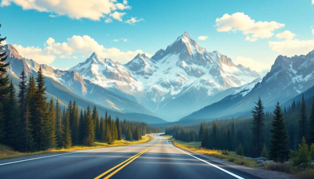
The Rocky Mountains stretch across North America with some of the continent’s most breathtaking landscapes, offering motorists an unrivalled opportunity to witness nature’s grandeur from behind the wheel. These majestic peaks, carved by ancient glaciers and shaped by millennia of geological forces, provide the backdrop for driving experiences that combine adventure with stunning visual spectacles. From winding mountain passes to high-altitude routes that seem to touch the sky, the Rockies present a collection of scenic drives that captivate travellers from around the globe, each route offering its own distinctive character and memorable vistas.
Alberta’s Scenic Drives: discovering the Rockies
The Canadian Gateway to Mountain Splendour
Alberta serves as the primary Canadian gateway to the Rocky Mountains, offering motorists access to some of the most spectacular wilderness areas in North America. The province’s position along the eastern slopes of the Rockies provides visitors with dramatic elevation changes and diverse ecosystems within relatively short driving distances. Banff National Park and Jasper National Park, both UNESCO World Heritage Sites, anchor the region’s scenic driving routes, presenting landscapes that range from turquoise glacial lakes to towering limestone peaks.
Highway Infrastructure and Seasonal Considerations
The province maintains an extensive network of well-engineered highways that balance accessibility with environmental preservation. Travellers should consider several factors when planning their journeys:
- Summer months (June through September) offer the most reliable weather and full facility access
- Early autumn provides spectacular foliage colours with fewer crowds
- Winter driving requires proper equipment and experience with mountain conditions
- Spring conditions can be unpredictable with lingering snow at higher elevations
Alberta’s commitment to maintaining these routes ensures that visitors can safely experience the region’s natural wonders whilst minimising environmental impact through carefully designed road corridors and viewing areas.
Amongst Alberta’s numerous mountain routes, one particular highway stands out as the jewel in the crown of Canadian scenic drives.
The Iconic Journey of the Icefields Parkway
A Corridor Through Ancient Ice
The Icefields Parkway stretches 232 kilometres between Lake Louise and Jasper, creating what many consider the most spectacular mountain drive in the world. This highway traverses the heart of the Canadian Rockies, passing more than 100 ancient glaciers and offering access to the Columbia Icefield, one of the largest accumulations of ice south of the Arctic Circle. The route climbs to elevations exceeding 2,000 metres, providing perspectives on landscapes that have remained largely unchanged since the last ice age.
Notable Stops and Attractions
| Location | Distance from Lake Louise | Key Features |
|---|---|---|
| Peyto Lake | 40 km | Distinctive wolf-head shape, vibrant turquoise colour |
| Columbia Icefield | 103 km | Athabasca Glacier access, ice explorer tours |
| Sunwapta Falls | 178 km | Powerful waterfall, accessible viewing platforms |
| Athabasca Falls | 199 km | Dramatic canyon, multiple viewpoints |
Wildlife viewing opportunities abound along this route, with frequent sightings of elk, bighorn sheep, mountain goats, and occasionally bears. The highway’s design includes numerous pullouts and interpretive sites that allow travellers to safely stop and absorb the magnificent surroundings.
Whilst the Canadian Rockies offer unparalleled beauty, the American Rockies present their own collection of remarkable mountain highways, beginning with a route known for its precious name.
The Enchanting Charm of the Million Dollar Highway
Colorado’s Engineering Marvel
The Million Dollar Highway forms a 40-kilometre section of U.S. Route 550 between Silverton and Ouray in southwestern Colorado. The origin of its name remains debated, with theories ranging from the cost of construction to the value of gold ore used in the road bed, or simply the priceless views it provides. This route navigates some of the most challenging terrain in the American Rockies, with steep grades, sharp curves, and minimal guardrails that demand full attention from drivers.
Historical Significance and Modern Appeal
The highway follows paths originally used by Native Americans and later by miners during Colorado’s silver boom. Today’s route incorporates sections of the historic Rainbow Route, a toll road built in the 1880s. The drive passes through:
- Red Mountain Pass at 3,353 metres elevation
- Historic mining towns with preserved Victorian architecture
- Dramatic cliff faces with exposed geological formations
- Alpine meadows that burst with wildflowers during summer months
The combination of natural beauty and human history creates a driving experience that engages both the senses and the imagination, offering insights into the determination of early settlers who carved routes through these formidable mountains.
Moving northward from Colorado, another high-altitude highway presents an equally thrilling journey through wilderness areas where wildlife outnumbers visitors.
The Impressive Route of the Beartooth Highway
Montana and Wyoming’s Alpine Masterpiece
The Beartooth Highway spans 109 kilometres between Red Lodge, Montana, and the northeast entrance of Yellowstone National Park in Wyoming. This route reaches an elevation of 3,337 metres at Beartooth Pass, making it one of the highest paved roads in North America. The late Charles Kuralt famously described it as “the most beautiful drive in America”, a sentiment echoed by countless travellers who navigate its switchbacks and plateaus.
Ecological Diversity and Viewing Opportunities
The highway’s dramatic elevation changes create distinct ecological zones within a relatively compact area. Travellers experience multiple climate zones and ecosystems:
| Elevation Range | Ecosystem Type | Characteristic Features |
|---|---|---|
| 1,700-2,400 m | Montane Forest | Lodgepole pine, Douglas fir, wildlife corridors |
| 2,400-3,000 m | Subalpine | Engelmann spruce, alpine meadows, mountain goats |
| Above 3,000 m | Alpine Tundra | Hardy grasses, persistent snowfields, marmots |
The highway typically opens in late May and closes with the first heavy snows in October, with the short season adding to its appeal amongst enthusiasts who plan their visits carefully to coincide with optimal conditions.
Colorado offers yet another spectacular high-altitude route that provides access to environments found nowhere else in the lower states.
The Unparalleled View on the Trail Ridge Road
Rocky Mountain National Park’s Crown Jewel
Trail Ridge Road traverses 77 kilometres through Rocky Mountain National Park in Colorado, with 18 kilometres running above the tree line at elevations exceeding 3,600 metres. This makes it the highest continuous paved road in the United States, offering perspectives on alpine tundra ecosystems that typically require extensive hiking to access. The route connects Estes Park on the east with Grand Lake on the west, crossing the Continental Divide at multiple points.
Alpine Environment and Safety Considerations
The extreme altitude and exposure create unique challenges and opportunities for visitors. The thin air at these elevations can affect even healthy individuals, and weather conditions can change rapidly. Key considerations include:
- Afternoon thunderstorms develop frequently during summer months
- Temperatures can drop below freezing even in July and August
- Strong winds are common, particularly at exposed viewpoints
- The road typically opens in late May and closes by mid-October
Despite these challenges, the rewards are extraordinary, with opportunities to observe elk, bighorn sheep, and marmots in their natural habitats, along with vistas that extend for hundreds of kilometres on clear days.
The final route in this collection takes travellers through one of America’s most beloved national parks, offering a driving experience that combines engineering achievement with natural wonder.
The Picturesque Circuit of the Going-to-the-Sun Road
Glacier National Park’s Architectural Triumph
Going-to-the-Sun Road stretches 80 kilometres across Glacier National Park in Montana, crossing the Continental Divide at Logan Pass. Completed in 1932 after 11 years of construction, this route represents a remarkable feat of engineering that harmonises with the landscape rather than dominating it. The road’s design earned it designation as a National Historic Landmark and recognition as a National Historic Civil Engineering Landmark.
Distinctive Features and Visitor Experience
The road’s narrow width and vintage design create an intimate connection with the surrounding environment. Modern large vehicles face restrictions, preserving the historical character whilst ensuring safety. Highlights along the route include:
- Lake McDonald’s crystal-clear waters reflecting surrounding peaks
- The Weeping Wall, where water cascades directly onto the roadway
- Logan Pass Visitor Centre at 2,026 metres elevation
- Hidden Lake Overlook trail, accessible from the pass
- Wild Goose Island viewpoint on Saint Mary Lake
The road typically opens in mid-June after extensive snow removal operations and closes in mid-October, with the brief operating season concentrating visitors into a window when wildlife activity peaks and wildflowers blanket alpine meadows.
These seven routes through the Rocky Mountains represent more than mere transportation corridors; they serve as carefully designed pathways that allow travellers to witness some of North America’s most spectacular landscapes whilst minimising environmental impact. Each highway offers its own character, from the glacial grandeur of the Icefields Parkway to the engineering marvel of Going-to-the-Sun Road. Whether seeking wildlife encounters, geological wonders, or simply the restorative power of mountain vistas, these scenic drives provide accessible adventures that create lasting memories and foster appreciation for the natural world’s magnificent diversity.